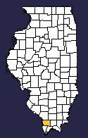


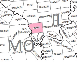
Union County, one of the fifteen counties into which Illinois was divided at the time of its admission as a State — having been organized, under the Territorial Government, in January, 1818. It is situated in the southern division of the State, bounded on the west by the Mississippi River, and has an area of 400 square miles. The eastern and interior portions are drained by the Cache River and Clear Creek. The western part of the county comprises the broad, rich bottom lands lying along the Mississippi, but is subject to frequent overflow, while the eastern portion is hilly, and most of its area originally heavily timbered. The county is especially rich in minerals. Iron ore, lead, bituminous coal, chalk, alum and potter's clay are found in considerable abundance. Several lines of railway (the most important being the Illinois Central) either cross or tap the county. The chief occupation is agriculture, although manufacturing is carried on to a limited extent. Fruit is extensively cultivated. Jonesboro is the county-seat, and Cobden and Anna important shipping stations. The latter is the location of the Southern Hospital for the Insane. The population of the county, in 1890, was 21,529. Being next to St. Clair, Randolph and Gallatin, one of the earliest settled counties in the State, many prominent men found their first home, on coming into the State, at Jonesboro, and this region, for a time, exerted a strong influence in public affairs. Pop. (1900), 22,610.
Source: Encyclopedia of Illinois
| Jackson | Williamson | |
| MO |
 |
Johnson |
| Alexander | Pulaski |